 The Bear Trap Fire in the San Mateo Mountain in western Socorro County has grown to 15,215 acres as of Tuesday and is 28 percent contained. Operations have been assumed by the Southwest Area Type 2 Incident Management Team 4, which brings additional resources and management capabilities to implement a full suppression strategy for the fire. Incident Commander is Aaron Hulburd.
Type 2 is a self-contained, all-hazard or wildland team recognized at the national and state level and is deployed as a team “to manage incidents of regional significance and other incidents requiring a large number of local, regional, state, and national resources.” This includes incidents where operations section personnel approach 200 per operational period and total incident personnel approach 500.
There are currently 540 personnel working the Bear Trap Fire.
In the meantime, the Magdalena Ranger District – along with other districts in Cibola National Forest – has moved to a Very High Fire Danger rating. The rating is based on the dryness of wood, grass and other combustible material, as well as weather conditions and the terrain.
According to officials, historically dry conditions and higher than normal temperatures along with increasing winds continue to test the Bear Trap Fire. These critical conditions are posing challenges to firefighters as the fire continues to advance further to the southeast.
The operational plan is to develop strategies to fully contain the fire while protecting valuable resources in the area, including natural and cultural resources and infrastructure.
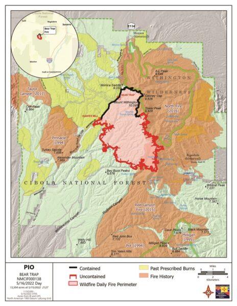
The containment is predominately on the north side of the fire as firefighters move south along existing roads to clear vegetation to help improve access and reduce fuels.
In addition, areas previously burned by prescribed fires and wildfires are helping to limit fire spread to the northwest, northeast and east, but the main fire continues to slowly advance to the southeast.
Smoke may be visible in the surrounding areas of Alamo, Datil, Magdalena, Socorro, and San Antonio. Smoke-sensitive individuals and people with respiratory problems or heart disease are encouraged to take precautionary measures. Information on air quality and protecting your health can be found at the New Mexico Department of Health Environmental Public Health Tracking website: nmtracking.org.
This week firefighters are constructing control lines using a combination of hand tools and heavy equipment to improve roads and connect into natural barriers, such as rock cliffs, to stop fire spread to the south. Crews are strategically applying low-intensity fire along main roads to the west and northwest to remove vegetation between the Bear Trap Road and the main fire, the statement says.
Elsewhere in the region, 141 firefighters are battling the Black Fire, 24 miles north of Mimbres in Gila National Forest. The Black Fire, discovered May 13, has grown to 56,132 acres and is zero percent contained.
The cause of the Black Fire is under investigation.
Stage 1 Fire restrictions remain in effect on the Gila National Forest to reduce the risk of human-caused wildfires.
Stage 2 fire restrictions remain in effect on the Cibola National Forest.
The New Mexico Fire Information website says there have been multiple drone incursions on the wildfires burning in Northern New Mexico over the past several weeks. The most recent took place on May 14 on the Cerro Pelado Fire in the Jemez Mountains.
“We can’t stress enough how dangerous drones are to firefighting efforts,” the statement says. “Please do not fly drones near wildfires.”
-
John Larson, El Defensor Chieftainhttps://dchieftain.com/author/jlarson/

-
John Larson, El Defensor Chieftainhttps://dchieftain.com/author/jlarson/
-
John Larson, El Defensor Chieftainhttps://dchieftain.com/author/jlarson/
-
John Larson, El Defensor Chieftainhttps://dchieftain.com/author/jlarson/