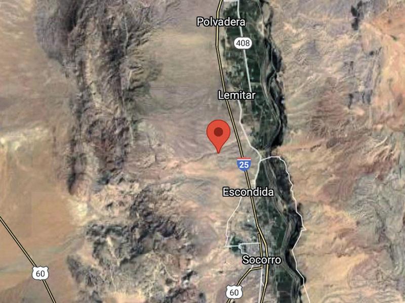
The epicenter was 4.8 miles beneath the surface in the Kelly Canyon Road area just west of Interstate 25.
Images courtesy of NM Bureau of Geology and Mineral Resources
Another rumbling was felt last week for residents in the Lemitar area and the north end of Socorro. On Tuesday at approximately 2:03 p.m., a magnitude 2.6 earthquake was felt by numerous residents and was recorded on seismometers operated by the New Mexico Tech Seismological Observatory. The facility is managed by Mairi Litherland, Ph.D.
“Although we monitor throughout the state of New Mexico, we do focus on the Socorro area,” Litherland said. “Because we’re here, and there are a number of earthquakes here, although we haven’t had too many lately.
“The one that happened on Tuesday is considered relatively small,” and on this occasion, many residents did not feel the earthquake, and no damage was reported, she said.
“I didn’t get any reports of damage, but mostly what people reported was hearing a sound and then some shaking,” Litherland said. “People had described the sound as a little bit like a train.”
She said input and reports from the public are useful.
“When an earthquake happens we record it on our sensors and get the magnitude and location,” she said. “But depending on the specific geology of the region, the way the shaking travels to different areas can be different. In some places, the shaking could go pretty far, but in other directions, it could be more localized. So, in terms of understanding how earthquakes impact people, getting these reports are extremely helpful.”
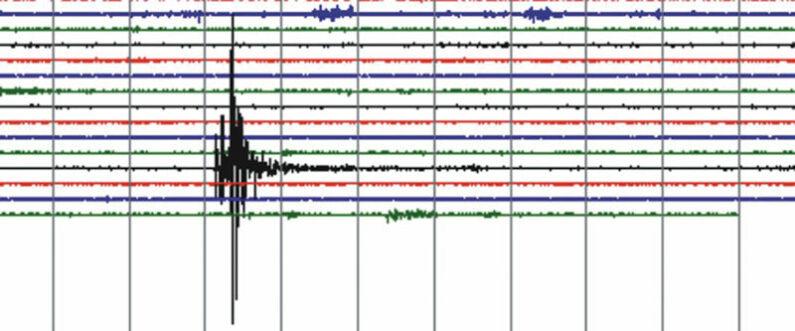
At approximately 2:03 p.m. on January 25 a magnitude 2.6 earthquake was felt by numerous residents and recorded on seismometers operated by the NMT
Seismological Observatory,
Litherland said she is often contacted when earthquakes happen in other parts of the state.
“In general, the Socorro area is susceptible to more earthquakes than the rest of New Mexico and that is due to the expansion of the magma body.”
Socorro County sits 12 miles over a blister of magma known as the Socorro Magma Body that has been slowly rising, which results in occasional tremblors.
“So, when the magma body expands, it can cause the Rio Grande Fault to react,” Litherland said. “The Rio Grande rift is basically the valley that the river flows down. It’s very, very slowly being pulled apart.”
There have been measurable earthquake swarms in the area in the last 40 years, and have generally been in the 3.5 magnitude range. The epicenter of the quake last week was 4.8 miles below the surface, according to Litherland’s instruments at the Bureau of Geology and Mineral Resources on the Tech campus.
Although New Mexico is geologically known to have had many volcanoes in the distant past, the chance of a large earthquake is minimal. Residents in the Socorro and middle Rio Grande region periodically experience earthquakes no stronger than in the two- to three-point on the Richter magnitude scale.
“This is actually the most seismically active area in New Mexico,” Litherland said.
The reason for that is the Rio Grande Fault.
The strongest recorded earthquake in Socorro was recorded in 1906, measuring near 6.0 in magnitude, one in a series of shocks or tremors felt in a six-month period between July 2, 1906, through early 1907.
-
John Larson, El Defensor Chieftainhttps://dchieftain.com/author/jlarson/

-
John Larson, El Defensor Chieftainhttps://dchieftain.com/author/jlarson/
-
John Larson, El Defensor Chieftainhttps://dchieftain.com/author/jlarson/
-
John Larson, El Defensor Chieftainhttps://dchieftain.com/author/jlarson/