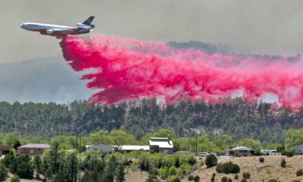
A study is documenting the existing features of the San Antonio I-25 interchange so that proposed alternatives for the interchange can be developed.
Courtesy graphic
The New Mexico Department of Transportation is in the process of reevaluating the design of the Interstate 25 interchange with Highway 380 at San Antonio. The study, which began in March 2022, looks at the stretch of highway between milepost 139 and milepost 140.
The DOT study notes that “the land surrounding the San Antonio interchange is primarily undeveloped and rural with little to no development directly adjacent to the interstate. Cattle grazing and agriculture are the primary land uses in the vicinity of the study area. Businesses and homes can be found half a mile to the east in the community of San Antonio.”
Mark Salazar, Project Development Engineer with NM DOT District 1 out of Las Cruces, said prior to the study, DOT was looking into the deficiencies and “came to determine a study was best for the interchange.
“The safety of the entrance ramps at 380 is the main reason,” Salazar said. “The District was looking at those ramps to see what improvements could be done and came to realize improvements required a full-blown study.”
He said the bridge and interchange date back to the 1960s. With the popularity of Bosque del Apache National Wildlife Refuge, as well as White Sand Missile Range’s Stallion Gate, Highway 380 travelers and two busy restaurants, the safety of the on-ramps and exit-ramps increasingly come into question.
“We were aware the merging distance and sight distance was poor, as well as the geometry of the ramps,” he said. “There have been a number of accidents there.”
According to Salazar, the study is documenting existing roadway geometry, drainage structures, bridge structures, and access control.
An initial public meeting for the study was hosted on November 16, 2022 where the study team identified areas of concern. Issues discussed included the geometry of the entrance and exit ramps and drainage.
“One significant part of this interchange study will be the Walnut Creek improvements,” he said. “Walnut Creek is a regional drainage channel that passes through the study boundary.”
Access control is another point of concern, he said.
“The access road on the western side of the interchange connects an unpaved rural road to the developed roadway system, and the intersection is in the entrance and exit ramp areas,” he said. “The potential for conflicting movements inherently created from this intersection is a safety concern for the interstate system.”
In addition, a total of five bridges fall into the interchange study area.
“Those 50-plus years old structures are reaching the end of their typical service life and are currently showing signs of dilapidation and disrepair,” Salazar said.
The study is going into its second phase, which could take another year.
“This is when we start developing proposed alternatives,” he said. “That’s what we’re doing right now. We do several designs to see which would be best suited for this location. We could replace the bridges, replace the ramps. Whatever addresses all the safety issues.”
Alternatives will be considered following a forthcoming public meeting.
“Now that we have some interchange improvement alternatives that have been identified and evaluated, we are hosting a second public meeting to present the alternatives and recommendations for the public’s review and input.”
The second public meeting will be virtual through Zoom and telephone on Monday, May 18, 6-7:30 p.m. Visit https://www.dot.nm.gov/event/i25sastudypublicmeeting2/ for details on how to attend.
-
John Larson, El Defensor Chieftainhttps://dchieftain.com/author/jlarson/

-
John Larson, El Defensor Chieftainhttps://dchieftain.com/author/jlarson/
-
John Larson, El Defensor Chieftainhttps://dchieftain.com/author/jlarson/
-
John Larson, El Defensor Chieftainhttps://dchieftain.com/author/jlarson/